
This walking and cycling trail takes in both urban Coatbridge and two of Lanarkshire’s rural waterways. It will lead us from Summerlee Museum of Scottish Industrial Life in Coatbridge to Hillend Reservoir near Caldercruix following the Monkland Canal and the North Calder Water. There will be lots of history along the way!

From the museum you can either walk down Heritage Way, or follow the path past the Summerlee play park along the route of the canal to where Coatbridge’s famous railway bridges span the site of the Monkland Canal.
Coatbridge Cross, at the beginning of Main Street, was where the Monkland Canal met with road, rail and pedestrian traffic. Today the canal through Coatbridge is piped underground but it is the reason there are so many bridges at this junction.
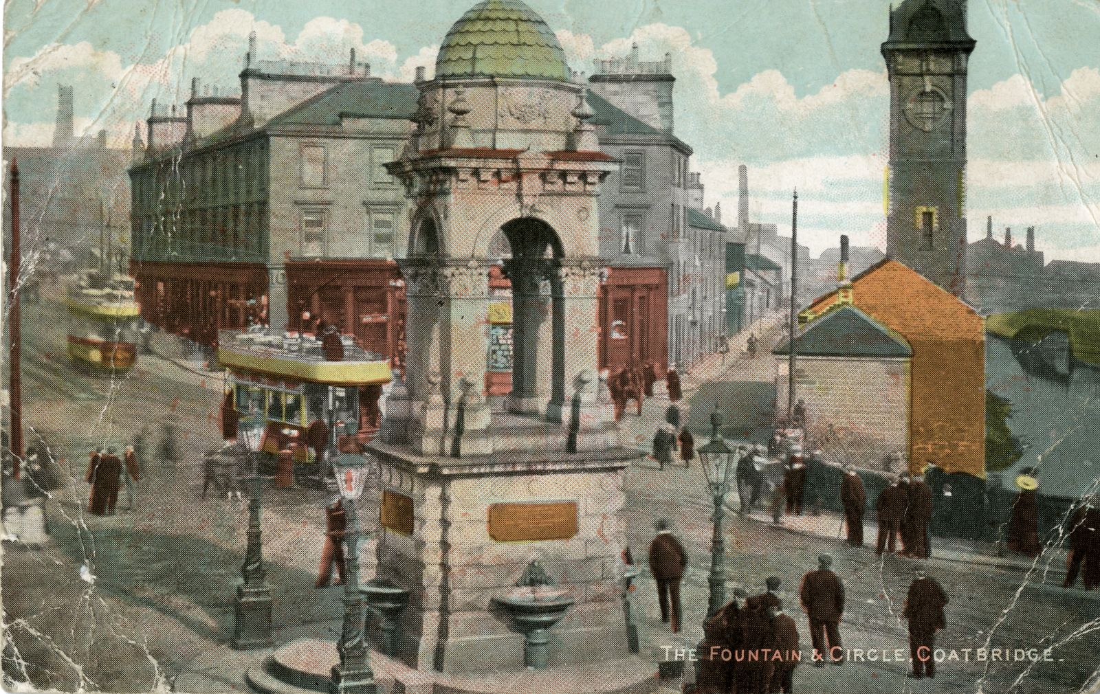
Coatbridge Fountain at the corner of Main Street and South Circular Road was built in 1890 in dedication to Alexander Whitelaw, the then manager of Gartsherrie Ironworks. He paid for the reorganisation of Coatbridge Cross, raising the level of the railway above that of the Canal. The fountain has been moved about several times.
Just before Coatbridge Cross we cross West Canal Street (watch out for speeding traffic) and then Bank Street at the lights. Turn left under the railway bridge and then the route follows Ellis Street to the right of the former cinema. On our left we pass the red brick building that was the Coatbridge Mines Rescue. This was the headquarters for the rescue service who would also train here. The basement had a mocked-up mine that could be flooded, while the garages for the rescue vehicles can still be seen at the back of the building.
Follow the road as it curves to the left and pass Coatbridge Police Station on the right. Turn right past the police station and take the ramp up to the health centre car park. Follow the access road past the health centre and petrol station and take the zebra crossing over Centre Park Drive.

We are now on a tree-lined path behind Tesco’s which follows the line of the Monkland Canal. The route is mostly traffic-free from now on.
Take the footbridge over Coatbank Street and turn left to continue on the path. Look left from footbridge: the roundabout at the top of Coatbank Street was the site of two of the town’s malleable ironworks, the Clifton and Phoenix Works, a completely different scene from today:

Further east we go under a swing bridge built to carry the Sheepford Branch of the Monkland & Kirkintilloch Railway over the canal.

The swing bridge that carried a railway line over the Monkland Canal, photographed in 2022.

We soon reach Locks Street. This area is called Sheepford. It was where the construction of the Monkland Canal began in 1770 under the supervision of James Watt. In the 1790’s, when the Canal was extended eastwards, a set of locks was built here. It was one of only two lock systems on the whole of the Canal. At the same time a road bridge was built over the Canal to carry Locks Street. You can still see this iron road bridge today.

Overhead is the Locks Street Railway Viaduct. It was built in the 1880’s and carried the Caledonian Line between Rutherglen and Airdrie. Its piers were orientated in an unusual way to accommodate the Monkland Canal underneath.

Locks Street Railway Viaduct, photographed in 2022. The leftmost pier is skewed to accommodate the line of the Monkland Canal, now filled-in.
The viaduct provides a good view of Coatbridge and what was once a heavily industrialised spot. To the north, we can see large whisky warehouses which are on the site of the Clyde Tube Works, the first such works built in the town.
Just below the viaduct on the right, a pallet yard is the site of the Rochsolloch Steel works. Here steel billets were rolled from the 1930’s to 1964. Prior to that it was a malleable ironworks and prior to that again, between around 1850 and 1859, it was a brickworks. Today only one small outbuilding remains.
The former Rochsolloch Primary School, high up on the right, is a fine nineteenth century red sandstone building that is now a business centre.
Further right still was Cairnhill Works. This works started as a malleable ironworks in the early 1900’s but switched in the 1920’s to making tubes under the name of the Imperial Tube Works. Like the Clyde Tube Works it was part of Stewarts & Lloyds, the largest producer of tubes in the world. The factory closed in the early 2000s, the last tubeworks in the Coatbridge/Airdrie area, and has been replaced by housing.
The Forth Clyde Cycle Route continues on to Airdrie along the line of the disused railway. However, we will follow the path down from the viaduct at its western end. Our route leads south and will follow the former route of the Monkland Canal to it’s end at Calderbank.
A short distance south of the viaduct, on the left hand side of the Trail, are the policy woodlands of Cairnhill Estate. Paths lead off from the Trail into the woodlands. Among the species that can be seen are beech, sycamore, Scots pine, oak, lime and chestnut.

Further on you come to Sikeside Road. Beyond that is a 4km remnant section of the Monkland Canal, with water still in it. Here on our right we start to see the North Calder Water for the first time, the two waterways running more or less parallel. Low Palacecraig, a single storey cottage on the opposite bank of the canal stands close to the start point of Lanarkshire’s first public railway, the Monkland and Kirkintilloch Railway. This line carried coal north to the Forth and Clyde Canal at Kirkintilloch.

To the east and north of the Canal is Palacecraig. Remnants of this areas mining history are evident along the canal in the form of a few burnt out and levelled coal bings. Here are new woodlands planted by the Central Scotland Countryside Trust as part of the Central Scotland Forest. On the hill to the north stands Palacecraig House. This 200 year old farmhouse is a reminder that amongst all this mining and iron-working farming continued to be an important industry.
This stretch of the Monkland Canal supports a range of wildlife. Herons, coots, ducks and moorhen are a common sight. There are also plenty of brown trout and pike in the water making it popular among local anglers. Much of the Canal has a covering of Great Water Grass which offers shelter to the wildlife in the Canal.
Further east along the Canal you come to a canal basin and the Lower Faskine Bridge. The basin may have been where, in 1819, the first iron boat in Scotland was made. It was called the Vulcan and was a passenger carrying canal boat, or Passage Boat, built for the Forth and Clyde Canal. Built with iron rolled at the nearby Monkland Steel & Iron Works, it was the forerunner of all the great iron and steel ships to be built in the west of Scotland. The original boat has long gone but a full size reconstruction of it is on display at Summerlee.

On the skyline is the former company village of Calderbank, built to house the families of ironworkers. Ahead, in the field bound by the pipeline is the former cricket pitch of Calderbank Cricket Club. Cricket was played here for over 100 years from the 1880’s.

The Monkland Iron & Steel Works and the company village of Calderbank, shown on the 1st edition Ordnance Survey map, surveyed in 1859 (courtesty of the National Library of Scotland).
The field and the extensive woodlands to the south are part of Faskine Estate. The woodlands were the grounds to Woodhall House and were laid out between 1750 and 1800.
The fenced-off footbridge across the canal here was originally built for one of the mine tramways. Horses would pull wagonloads of coal along these small railway lines.
Just beyond the end of the Canal you can see a dam on North Calder Water. This dam was constructed in 1792 to control the flow of water into the Canal.


The Trail now follows the river all the way to Hillend Reservoir. A short distance on the path goes through a tunnel under a road bridge. This tunnel was built to maintain the connecting railway line between Monkland Iron and Steel Works and the Monkland Canal. Passing through the tunnel you enter the site of Calderbank Steel works. It was here that the iron was rolled for the first iron passenger vessel, the Vulcan (1819). Over a hundred years later steel plates for the ocean liner Queen Mary were made on almost exactly the same spot.
Today, a natural birch, oak and ash woodland has regenerated the site. The first part of is entirely built up from slag from the period when steel was produced here . Beyond this there is a clearing in the valley marking the site of the actual works. On the left hand side in this area is the blast furnace platform from the period when iron was produced here. The wall, was much longer that it appears today. The platform enabled the six blast furnaces (each around 20 metres high and situated along the foot of the wall) to be charged (filled with raw materials) from the top.
Continuing along the Trail you come to a weir on the river. This was the main extraction point of water for the works. Water was used to power large mechanical hammers and also for cooling.
The main route of the Trail goes up to the right but take time to explore the path on the other bank of the river on your right. A short distance on you come to a retaining wall and terrace for the work’s mineral lines. The wall is made from huge drums cast from the waste from puddling furnaces during the period when malleable iron was made here.

Drums of slag solidified into the shape of the inside of a slag lade, stacked up to support an embankment in the woods at Calderbank, April 2022 (photo: Justin Parkes).

Back on the main route of the Trail the path goes up some steps. Soon you come to a huge railway viaduct pier. The line was entirely separate from the works below and carried passengers from Airdrie to Newhouse. It opened in 1887 and closed in 1939.
All along the Trail there are areas rich in wildflowers. In some instances industry has benefited wildflowers. Slag, coal bings and disused railways often offer a well-drained surface, which is ideal for flowers like ox-eye daisy, wild strawberries, St John’s wart, bird’s foot trefoil and orange hawkweed. Feeding on these wildflowers are butterflies like the meadow brown and the common blue.
Wetter grassland areas support wildflowers like common spotted and butterfly orchids, cranesbill, great willow herb and meadow sweet.

The Trail continues north through woodlands to Monkland Glen where a footbridge crosses over North Calder Water, underneath the road bridge.
On the west bank of the river where the housing is, was where Monkland House used to be. It was a magnificent sixteenth century house with gardens and policy woodlands, some of which is still preserved along the Browns Burn. The managers of iron and steel works at Calderbank stayed here from the late 1700s and the house later became a hotel. Sadly, the building was demolished in the early 1980s following a series of fires.
On the north side of the road bridge was where Monkland Forge used to be, one of many 1800s water powered forges making spades for the coal mining industry.
Further north the valley becomes a gorge and the woodlands become dense. The woodlands are mostly oak and ash with hawthorn and some non-native species like beech and sycamore. The woodlands flanking North Calder Water offer a welcome environment for the kingfisher. The dipper and heron are other birds to look out for along the river. Such has been the improvement in the river quality over the years that otters now live there. On the north bank, the site of Moffat Upper Forge (which operated from sometime before 1845 to 1867) was excavated by archaeologists in the early 2000s. They found the remains of a puddling furnace where malleable iron was made. A ‘bear’, or part of the furnace lining with slag that was removed when the furnace was renewed, was found and is now in the museum collections at Summerlee.

Descending down from Petersburn Estate the Trail crosses the river. At this point, at the side of the path, you can see waste paper from the old settling ponds of Moffat Mills Paper Mill. Beyond this on the left hand side of the path is a green mossy area, which was on old settling pond as well. Moffat Mills occupied the area now occupied by housing to the left of the path. A weir further upstream is the only structure that is left.
On the opposite side of the river are huge warehouses storing whisky. At one time whisky was made here but today it is just a store.

Beyond Caldervale High School the Trail ascends a hill and goes through a copse of beech trees, at one time the grounds of the nearby Wester Moffat House, now a hospital.
We join Airdrie Road for a time before turning right onto Brownieside Road which leads to Plains Country Park. You might want to spend some time exploring the park.
Just to the west of the Park is a weir and lade which drew water off to a grain mill called Brownieside Mill. The building to the east was part of Ford Forge and is the only mill building on the whole river to have survived.
Beyond the village we pass an old farmhouse called Loadmanford and beyond that we have the option to leave Main Street and turn left onto National Cycle Route 75. This briefly loops north before follownig the railway line to Caldercruix. If you stay on the road you will shortly turn right under what was known as the Fair Brig. Built when the North British Railway line was constructed here, the bridge was completely reconstructed shortly before the Bathgate line reopened in 2011.
If you continue on Airdrie Road, after the bridge on your right hand side are some large sandstone buildings. The buildings on the north side of the road were lived in by the managers of Caldercruix Paper Mill. On the south side is the old Caldercruix Public School built in 1875, a church and The Craig Institute. The Institute was built in 1908 by the mill owner to provide facilities for mill workers and has that date above the front door. The institute had a dining room, recreation room and library.

Meal-time at the Craig Institute, Caldercruix, around 1920.
Caldercruix Paper Mill was the largest produced of rag blotting paper in the world. All that remains today are the old settling ponds just opposite the artwork called Legs.

Sited across the road from the institute, where the new houses are, the paper mill was owned by Robert Craig & Sons, who also owned Moffat Mills.
The Trail passes through the village and out the other side where, on a railway viaduct you pass another artwork called steam.
A short distance further on the Trail enters Caldercruix Countryside and Nature Park. This Park is also managed by volunteers and is a place for the local community and visitors to enjoy the countryside.
The tallest trees are beech trees and a few Scots pines – a legacy from the grounds of Hillend House. Little remains of this house, built just beside the dam bank for the manager of the Forth and Clyde Canal.
The Park looks out on to Hillend Reservoir. When it was finished in 1799 this was considered to be the biggest man made reservoir in Scotland. The Reservoir is one of the best angling lochs in Central Scotland and is popular for sailing. Between October and April it is also a great place to see ducks and geese.
This is the end of the North Calder Heritage Trail but if you are feeling adventurous, there is a traffic-free trail to Cumbernauld.