The Monkland Canal, which fully opened in 1793 was built to take coal from the mineral-rich area of the Monklands to the growing city of Glasgow and beyond.

The Monkland Canal’s branches, as seen on the first Ordnance Survey Map from the1850s. The canal is highlighted in blue and the branches in red (National Library of Scotland).
As soon as the canal was completed new mines and other industries sprang up along its banks and over several decades, new branch canals (or ‘cuts’) were dug to connect the canal with nearby mines and with Lanarkshire’s first public railway lines.
Here we are going to look at the five canal branches that were in or near Coatbridge (there was a sixth in the Townhead area of Glasgow). You can explore them yourself on foot or via the National Library of Scotland’s online maps.
1. Dixon’s Cut

Dixon’s Cut on the 1859 Ordnance Survey map. The branch meandered from Sheepford Locks on the Monkland Canal to William Dixon’s Calder Iron Works (National Library of Scotland).
The easternmost branch of the canal meandered south for about a mile from Sheepford Locks to William Dixon‘s Calder Iron Works. This works had opened in the 1790s, shortly after the canal itself, and was the first of Coatbridge’s six pig iron works that would give the town the name of the ‘Iron Burgh’.

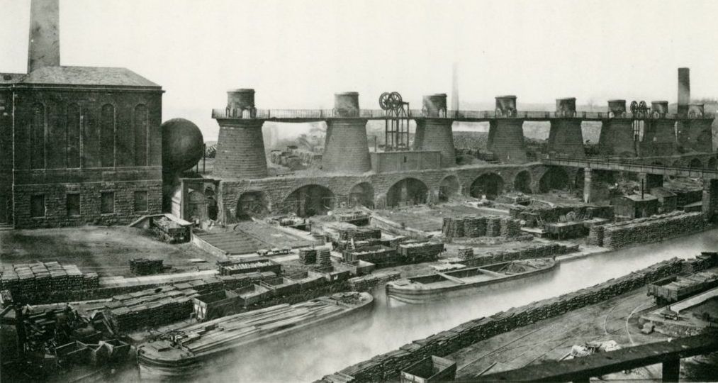
The Calder Iron Works, Coatbridge around 1900, seen from across the North Calder Water. Built around 1795 this was the Monklands’ first pig iron works. After David Mushet was made manager in 1800 the Calder was the first ironworks to make use of the local blackband ironstone. It was also one of the first ironworks to successfully use James Beaumont Neilson’s Hot Blast process. The works closed in 1921.

The photograph above shows Sheepford Locks during the infilling of the canal in 1965. Dixon’s Cut started on the right hand side of the basin in the centre of the picture, roughly where the mobile crane is. However, the canal branch had already been infilled here, in the late 1800s.

Dixon’s Cut in the 1890s. By this time what was left of the canal branch was derelict and no longer joined up with the Monkland Canal (National Library of Scotland).
In the late 1800s Dixon’s Cut fell out of use and was severed from the Monkland Canal by a new railway line and by the dumping of slag waste from the ironworks. By the 1950s new housing had completely erased what was left of the canal branch.
2. The Dundyvan Branch

The Dundyvan branch, seen on an 1890s Ordnance Survey map. The small canal basin that survives is circled in red (National Library of Scotland).
This branch of the canal served the Dundyvan Iron Works, which was a large complex that had both blast furnaces to make pig iron and a neighbouring malleable ironworks where the pig iron was refined to make it useable for engineering. Dundyvan had the biggest canal basins of any of the branches of the canal. These were built by the Monkland Canal Company around the late 1830s to enable the transfer of coal from the new railway lines nearby onto the canal.

This small basin marked the southern end of the Dundyvan branch and is now the only remaining part of it. At the far end there would have been a bridge so that canal boats could travel under the North British Railway line. Beyond the railway we can see the back of the bingo hall at Faraday Retail Park. Photographed in April 2023.
The Dundyvan branch remained open but disused until the canal through the town centre was filled-in in the 1960s. Traces can still be found, such as the short viaduct that carried the Caledonian Railway over the rail sidings that served the canal basins. Near the viaduct is a small canal basin to the south of the former North British Railway line.

This viaduct at Dundyvan was for local industrial railway lines to go under the Caledonian Railway. These lines connected the Dundyvan Iron and Steel Works with the Dundyvan branch canal and the North British Railway, both of which lay behind the photographer. Photographed in April 2023.
3. The Gartsherrie, Hornock and Summerlee Branch
The only branch of the canal to still exist originally ran from near the fountain in Coatbridge to Gartsherrie. Today the section that is in water ends inside the grounds of Summerlee Museum, with the dry bed extending as far north as the Glasgow-Edinburgh railway line. Originally the canal continued north of what is now Gartsherrie Road.

Gartsherrie Iron Works ‘New Side’, around 1875.
Two ironworks were built on the Gartsherrie Cut: William Baird and Company’s Gartsherrie Iron Works straddled the canal, with rows of eight blast furnaces on either side, while the Summerlee Iron Works occupied a site half-way along the branch, on its western bank. Howes Basin was built around the same time as the ironworks, in order to transfer coal from the railway to the canal.

A trip up the canal branch on the Firequeen, Summerlee Museum’s steam-powered boat.
This section of canal is now a Scheduled Monument, protected by law.
4. The Langloan Branch

The route of the Langloan branch seen on the 1890s Ordnance Survey map and a modern satellite photograph (National Library of Scotland).
This cut ran south from the canal to the Langloan Iron Works and ended in a substantial basin. The site of the basin is still an open area today, largely a car park, so it is easy to get an idea of its scale.

The site of Langloan Basin in 2023, looking east. Langloan Iron and Chemical Works once stood beyond the furthest trees.
At Langloan the canal is supported on a high embankment and so was the part of the Langloan branch nearest the canal. You can still be see the embankment, although it now supports two housing blocks, Merryston Court and Blairgrove Court.
5. The Drumpellier Branch

Ordnance survey maps of the Drumpellier canal branch in the 1850s and the 1890s (National Library of Scotland).
This little-known branch was short-lived, perhaps because it was the only one that wasn’t used by the iron industry. The cut was a short spur on the Drumpellier Estate to the west of Coatbridge and connected with a series of small coal pits to the north of the canal. The wealthy Buchanan family had made their fortune through the tobacco trade and owned large estates in Virginia where they enslaved people to cultivate and pick the tobacco. The Monkland Canal gave Andrew Buchanan new sources of revenue, including by leasing parts of the estate for mining coal.
The Drumpellier branch was largely filled-in by the 1890s. This was presumably either because mining had become concentrated at the Summerlee Iron Company’s Drumpellier Colliery No.3 and 4 pits which were right on the main canal, making a branch unnecessary, or to allow for construction of the North British Railway line through the estate.
It is still possible to spot where the branch started as the Monkland Canal is a little wider at the point where it used to be. It now lies in Drumpellier Country Park where the canal is in water and teeming with wildlife. If you would like to help care for the Monkland Canal you can find the Friends of the Monkland Canal on Facebook. For more information on Scotland’s canal network visit Scottish Canals.